[I’ve made brief corrections to this post regarding aspects of hydraulic mining, after a commenter pointed them out to me. And a more recent post goes into matters at more length, on points where I was wrong, and others on which I disagree with the commenter.]
We took our new English Mastiff Jack for his first off-leash walk in the woods this morning. He is a 3 1/2 year old rescue who has been with us for nearly a month now. He has settled in very well, comes when called at home even if he is barking at the UPS guy, and so we thought he was ready for an off-leash ramble. Our elderly female Rhodesian Ridgeback went too.
The nearby Gin Lin Trail is named for a Chinese mine owner and “traces the remains of a late-nineteenth-century hydraulic gold mining operation in what was known as the Palmer Creek Diggings, now a part of the Rogue River National Forest.” [more info]
Hydraulic mining used huge pressurized streams of water to turn hillsides or mountainsides into slurry that could be run through sluice boxes to trap the gold. The photo below shows a large-scale operation in action, somewhere in this area of the Oregon Siskiyous, in the latter half of the 19th century. For scale, notice the tiny figure of a man wearing a white shirt, tending the left-hand water hose.
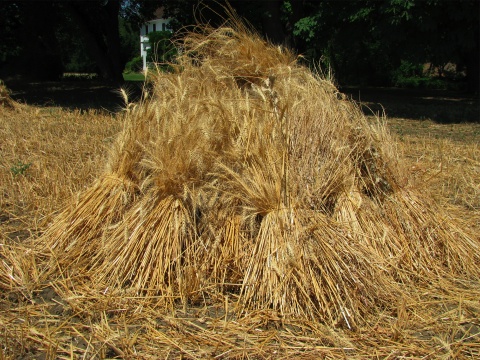
The tremendous destruction takes geologic time, not human time, to heal. Huge clefts are made in the land, piles of big rocks and new hills of “processed” dirt are put anyplace convenient, and the subsoil brought up doesn’t support plant life as well as the now-buried topsoil did. All this is easily seen along the Gin Lin Trail.
The picture above shows a steep slope of discarded material a steep-sided ditch, probably hand-dug to accommodate the miners’ equipment—sluice boxes or water pipes. Both the angle of the slope, and the composition of the material itself, are hostile to plant growth. Even on the top where it is closer to level, trees and shrubs are not as numerous or healthy as in undisturbed areas.
Miners blasted away tons of earth trying to follow layers of gold-bearing gravel laid down by ancient rivers. This picture (below) shows a cut made by their work, at the point where they stopped. making ditches like this.
And here’s some of the big river rocks moved as the mining went on.
The gold being sought had been deposited by watercourses running down to the river below, seen in the background of this picture. was in layers of Tertiary-era gravel, laid down in the bottoms of rivers 40 – 100 million years ago. Since then the river bottoms have been pushed up by geological forces, and cut through by new drainage systems. The ancient rivers may have had no connexion to existing rivers, since drainage patterns have changed.
Looking over the fence, from the same spot as the previous picture.
The dogs had a good time, and Jack stayed close and came when called, as we expected.
Because of the mining, it isn’t the best place for wildflowers, but we saw a few. This is Elegant Cat’s Ear (Calochortus elegans); the common name refers, I believe, to the fuzziness and triangular shape of the flower petals. This doesn’t show the plant’s leaves but there’s a good photo on Flickr that does.
Lupines don’t mind disturbed soil as much as many other plants do.
I think this is the Yellowleaf Iris, Iris chrysophylla.
And below, Iris bracteata, Siskiyou Iris. [caveat: I’m no expert on wildflowers so my identifications are not guaranteed! This USFS page has photos, range maps, and descriptions of the Pacific Coast iris species.] In our experience, this yellow-flowered iris is less common around here than Iris chrysophylla, the Yellowleaf Iris.
Below is my least favorite native plant around here, the glossy-leafed Poison Oak, Toxicodendron diversilobum.
In spring its leaves are usually glossy like this, and may be reddish too. On another plant it would be attractive but to me, the shiny fresh leaves are as ominous as the froth on a bodysnatcher pod.
We found it along most of the trail, flourishing as if it had been thickly planted and then fertilized and tended. If only my plants at home looked so good! Ravines were choked with it, and of course the dogs wanted to go running down into such places. I don’t think I’ve ever gotten poison oak from a dog’s coat, in all these years of living here, but there’s always a first time. I’ve often gotten it from secondary sources like clothing or even the touch of someone else’s hand. (In a post last year I described something that helps lessen the itching and make the blisters go away faster.)
The damned stuff was everywhere. Every plant visible in the photo below is poison oak.
Finally the trail ahead was overgrown with it and we gave up and headed back. The dogs ran ahead, enjoying the downhill rush, and got out of sight as we neared the small parking area, where I heard excited voices. It turned out to be the teenage park maintenance crew and their adult supervisor, cruising the areas to do things like gather up garbage strewn around by animals during the night. They were excited by the sudden appearance of a dog who outweighed most of them, and Jack had been pleased to see them but hadn’t bowled anyone over or been a pest. He’s a sweet affable guy except when defending his home turf, and even then has a good sense of proportion.
We loaded up our tired dogs, filled their water dish in the car, and headed home.
Thirsty dogs drink from the birdbath.


