
[I’ve made brief corrections to this post regarding aspects of hydraulic mining, after a commenter pointed them out to me. And a more recent post goes into matters at more length, on points where I was wrong, and others on which I disagree with the commenter.]
We took our new English Mastiff Jack for his first off-leash walk in the woods this morning. He is a 3 1/2 year old rescue who has been with us for nearly a month now. He has settled in very well, comes when called at home even if he is barking at the UPS guy, and so we thought he was ready for an off-leash ramble. Our elderly female Rhodesian Ridgeback went too.
The nearby Gin Lin Trail is named for a Chinese mine owner and “traces the remains of a late-nineteenth-century hydraulic gold mining operation in what was known as the Palmer Creek Diggings, now a part of the Rogue River National Forest.” [more info]
Hydraulic mining used huge pressurized streams of water to turn hillsides or mountainsides into slurry that could be run through sluice boxes to trap the gold. The photo below shows a large-scale operation in action, somewhere in this area of the Oregon Siskiyous, in the latter half of the 19th century. For scale, notice the tiny figure of a man wearing a white shirt, tending the left-hand water hose.

The tremendous destruction takes geologic time, not human time, to heal. Huge clefts are made in the land, piles of big rocks and new hills of “processed” dirt are put anyplace convenient, and the subsoil brought up doesn’t support plant life as well as the now-buried topsoil did. All this is easily seen along the Gin Lin Trail.

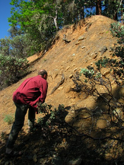
The picture above shows a steep slope of discarded material a steep-sided ditch, probably hand-dug to accommodate the miners’ equipment—sluice boxes or water pipes. Both the angle of the slope, and the composition of the material itself, are hostile to plant growth. Even on the top where it is closer to level, trees and shrubs are not as numerous or healthy as in undisturbed areas.
Miners blasted away tons of earth trying to follow layers of gold-bearing gravel laid down by ancient rivers. This picture (below) shows a cut made by their work, at the point where they stopped. making ditches like this.
And here’s some of the big river rocks moved as the mining went on.

The gold being sought had been deposited by watercourses running down to the river below, seen in the background of this picture. was in layers of Tertiary-era gravel, laid down in the bottoms of rivers 40 – 100 million years ago. Since then the river bottoms have been pushed up by geological forces, and cut through by new drainage systems. The ancient rivers may have had no connexion to existing rivers, since drainage patterns have changed.

Looking over the fence, from the same spot as the previous picture.

The dogs had a good time, and Jack stayed close and came when called, as we expected.


Because of the mining, it isn’t the best place for wildflowers, but we saw a few. This is Elegant Cat’s Ear (Calochortus elegans); the common name refers, I believe, to the fuzziness and triangular shape of the flower petals. This doesn’t show the plant’s leaves but there’s a good photo on Flickr that does.

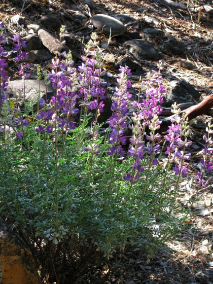
Lupines don’t mind disturbed soil as much as many other plants do.
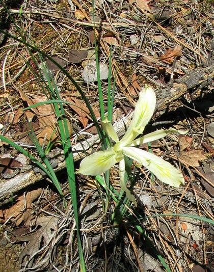
I think this is the Yellowleaf Iris, Iris chrysophylla.

And below, Iris bracteata, Siskiyou Iris. [caveat: I’m no expert on wildflowers so my identifications are not guaranteed! This USFS page has photos, range maps, and descriptions of the Pacific Coast iris species.] In our experience, this yellow-flowered iris is less common around here than Iris chrysophylla, the Yellowleaf Iris.
Below is my least favorite native plant around here, the glossy-leafed Poison Oak, Toxicodendron diversilobum.

In spring its leaves are usually glossy like this, and may be reddish too. On another plant it would be attractive but to me, the shiny fresh leaves are as ominous as the froth on a bodysnatcher pod.

We found it along most of the trail, flourishing as if it had been thickly planted and then fertilized and tended. If only my plants at home looked so good! Ravines were choked with it, and of course the dogs wanted to go running down into such places. I don’t think I’ve ever gotten poison oak from a dog’s coat, in all these years of living here, but there’s always a first time. I’ve often gotten it from secondary sources like clothing or even the touch of someone else’s hand. (In a post last year I described something that helps lessen the itching and make the blisters go away faster.)
The damned stuff was everywhere. Every plant visible in the photo below is poison oak.

Finally the trail ahead was overgrown with it and we gave up and headed back. The dogs ran ahead, enjoying the downhill rush, and got out of sight as we neared the small parking area, where I heard excited voices. It turned out to be the teenage park maintenance crew and their adult supervisor, cruising the areas to do things like gather up garbage strewn around by animals during the night. They were excited by the sudden appearance of a dog who outweighed most of them, and Jack had been pleased to see them but hadn’t bowled anyone over or been a pest. He’s a sweet affable guy except when defending his home turf, and even then has a good sense of proportion.
We loaded up our tired dogs, filled their water dish in the car, and headed home.

Thirsty dogs drink from the birdbath.

I felt like I was there with you! You see the same type of things I do, only more and better. Lovely photos.
Though your photos are great, it would be nice if you had done some research before attempting to inform others.
For example, in your second photo, you state that “Miners followed “pay streaks” of gold that might be only a hand’s-breadth wide, through the ground, making ditches like this.”
For starters, hydraulic miners never followed “pay streaks”. A pay streak is a modern term used to describe a gold deposit that has formed in an existing waterway. Though pay streaks can have varying widths, they are never just a width of a person’s hand. Secondly, your photo is NOT of a ditch, but two tailing pilings. These are not from hydraulic mining, but the use of hand tools and are probably more recent than the loose tailings you see in these photos.
Photo #3 is not discarded material, but unworked ancient river channel that is 100+ million years old. Your photo clearly shows the layers of streambed which have been exposed. Either the operator never got around to working this material or it carried too low of a value to work out. The top level is undisturbed from the standpoint of mining. Were it not, what you would see is a loose pile of cobbles as seen in your other photos. The small material between the cobbles would have been washed through a tailrace and ultimately wound up in the river. The reason you see very little growth even on the top level is that there is a tendency in areas with these ancient channels for the soil to be quite poor. I have visited many hydraulic mines (including several much bigger than this one) and in my experience, the deeper they were worked, the better the vegetation has recovered. In the case of the Old Channel Mine, the lushest growth in that area is actually in the deepest section of the bowl. The growth you see in these photos is actually pretty typical of areas dominated by ancient channel, even if no mining took place.
Also you state that “The gold being sought had been deposited by watercourses running down to the river below, seen in the background of this picture.”
That is not accurate. What you are looking at is an ancient river channel from the Tertiary period that is eons older than the waterway below it (the Applegate, in this case). Most of the gold in our richest modern creeks and rivers has gotten there by the current streams actually cutting into these ancient channels.
I hope this gives you a few insights into what you are looking at it when you visit this and similar areas, as it is very important for all of us to understand our local history.
Kerby,
Your comment spurred me to learn more about hydraulic mining, for which I thank you.
I’ve made brief corrections to the original post, and then wrote a new post to talk about the corrections, a couple of points where we still disagree, and then more about the effects of hydraulic mining in California.
I certainly agree with you on the importance of us understanding our history, local and otherwise.
Kerby, Are you aware how snippy your wording is? Perhaps you didn’t mean to be so, but it is easier for all of us to accept corrections if they are phrased in a friendly manner. This is a lovely blog and I think we’ll all enjoy it more if we comment in a helpful and kindly manner.
Ann… I agree with you about this being a beautiful blog and I enjoyed the pictures and the text. But… You are being way too PC. Face the fact that some of the facts were incorrect. Kerby is obviously very educated concerning gold mining and possibly geology. His comments and corrections were straight forward and were not rude. I think he did an excellent job correcting some innocent non-facts and the blog is better for it.
Well, Ann, if you felt that I was snippy, I apologize, because it certainly wasn’t intended that way.
I do however, feel that it is important for people to understand what they are looking at and I tend to be rather straight forward about it. There are a lot of opinions floating around SW Oregon about mining and while people are free to have their opinions, there is also a lot of misinformation being circulated, which is in turn, then recirculated as “fact”. Quite often these “facts” are then used to influence public opinion and to attempt to create legislation that is often not in our best interest. I say “our”, because anti-mining legislation also tends to include rules and regulations that also hamper agriculture, the timber industry, other types of public land use and in many cases, even private property rights. Needless to say, it is important that sound facts and sound science are given to the public. Regardless of the outcome, we can then at least say “Well, people made their decision on sound information.”.
That said, I do appreciate your willingness to listen, your willingness to learn and perhaps most importantly, your character. Many people would simply not bother to correct something they’ve written when told they are incorrect and I think it shows some real mettle when people are willing to correct something incorrect.
Hi Kerby,
Glad you stopped by again. My follow-up post is at https://nosleepingdogs.wordpress.com/2010/09/17/more-about-hydraulic-mining-including-some-corrections/
You and I are in perfect agreement about the importance of being accurate. It’s a responsibility to the readers, and also when I’m informed that I’m wrong it makes me go and research and learn more. All of our public discourse these days could use much more calm exploration of facts, insofar as facts can be established, and of the pros and cons of issues too.
If you can refer me to some resources on dredging and rivers, i.e. effect on rivers, I’d appreciate it. A recent letter-writer to the Medford Mail Tribune asserted that dredging improved fish spawning habitat, but gave no references for that.